
Students Head To Belize For GIS Mapping and Teaching
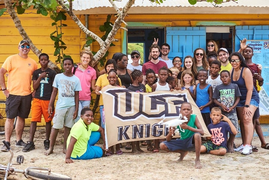
UCF study abroad students and Hopkins youth at the education outreach program. Photo credit: Tyler Copeland, UCF undergraduate student
BY TIM HAWTHORNE, Ph.D.
Opening up one’s worldview. Exploring foreign landscapes. Interacting with new cultures. Engaging in research with communities. These are just some of the things that a group of 11 UCF students did this May with the UCF Participatory Geographic Information Systems (GIS) study abroad class in Belize. The class is part of the larger Citizen Science GIS at UCF work led by Associate Professor Timothy Hawthorne, Ph.D., of the Department of Sociology.
While in Belize, students visited multiple locations around the country, and their trip included two community-based research projects. First, they worked in the small coastal village of Hopkins. The village of nearly 3,000 residents recently upgraded its water system, yet no mapped data about the new system had been shared with the community. UCF students partnered with the village council and the water board to map over nine miles of pipelines and over 550 water meters to support this new infrastructure using Esri’s Collector for ArcGIS, a mobile mapping application. The maps and data will soon be available as free, downloadable resources on the Hopkins Village Open Data Mapping Portal created by the Citizen Science GIS team using Esri’s ArcGIS Online platform.
“The data collection in Hopkins was a truly enlightening experience as it allowed us to make a connection between GIS methodologies and their real-world applications. Also, having conversations with local residents during this process led me to a deeper understanding of the culture in Belize and how it compares to my own culture,” said Larissa Gehringer, UCF Honors College and Biology undergraduate student.
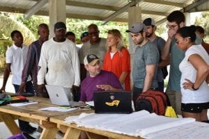
Hopkins water board members, UCF students and Hawthorne discuss mapping water pipelines and meters in the village. Photo credit: Tyler Copeland, UCF undergraduate student.
The second project saw students head out on the Caribbean Sea on a 45-minute boat ride off the mainland of Belize to South Water Caye, a small island located on the edge of the Belize Barrier Reef. Students worked with local guides, boat captains and resort managers to update the island’s snorkel and kayak map for tourists. The fieldwork included some students in kayaks with iPads and GPS units mapping points, while snorkeling students took notes and surveyed key points of interest underwater along the reef.
“Collecting data through snorkeling enabled us to get information for the people leading the operations in South Water Caye. We used the data that we gathered to create maps for visitors to view and interact with. Plus, we had the opportunity to see some amazing coral reefs and colorful fish!” said Ilan Gritzman, UCF public administration undergraduate student.
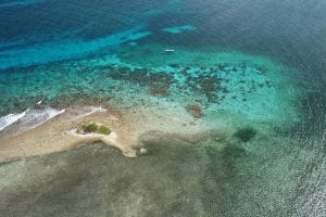
UCF students snorkel and kayak along South Water Caye Marine Reserve collecting data for a new tourism map of the area. Drone photo credit: Timothy Hawthorne.
In addition to their research, UCF students also hosted a youth education outreach program in Hopkins Village. Nearly 25 children participated in hands-on mapping and drone activities. The highlight of the education program was when the youth earned their pilot wings flying Parrot Mambo mini-drones at the library.
The 10 day trip to Belize also included introductory GIS training in the UCF classroom before and after the trip on the UCF campus. At UCF, students learned basic GIS techniques and worked as a team to complete the mapping projects. Only a handful of students had previous GIS experience, which makes the research projects even more exciting.
“A class like this shows the power of collaboration, and what can happen even when students and communities are just learning these new technologies for the first time. I hope more students have the opportunity to study abroad in their college careers. There is nothing quite like the experience of visiting a new place with a new group of people while doing community-based research. It’s a humbling and empowering experience for our students, and it supports communities abroad as well,” said Hawthorne.
The Belize GIS study abroad course runs again in Summer A 2020. To learn more about the class and the work of Citizen Science GIS at UCF, please visit www.citizensciencegis.org.