Citizen Science GIS Team Awarded for Spatial Storytelling

By Zenaida Gonzalez Kotala
Esri, a leader in spatial analytics, recognized a team from the University of Central Florida with its Special Achievement in GIS Award during the annual Esri User Conference last week.
Citizen Science GIS, a collaborative effort led by UCF geographic information system Assistant Professor Tim Hawthorne, was among the 180 selected from more than 300,000 nominees around the world. They were selected for their innovative use of GIS to capture, store, manage, and present spatial or geographic information.
“The SAG Awards provide a great opportunity to showcase all the outstanding achievements of our users,” said Jack Dangermond, Esri founder and president. “The Special Achievement in GIS Award recognizes exemplary organizations implementing spatial analytics technology to change the world.”
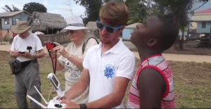
UCF’s Citizen Science GIS champions innovative, community-based applications of GIS, drones, and spatial storytelling to examine social and environmental inequalities. Some of the group’s major research areas focus on flooding and disaster management, coastal and community development, accessibility to social services, coastal restoration and preservation, and beach debris in Florida and Belize. All of the data is shared as open data through Esri platforms to stimulate research, discovery, education, and citizen science. Citizen Science GIS emphasizes student research experiences, most notably through the National Science Foundation Research Experiences for Undergraduates Site in Orlando and Belize focused on community GIS and citizen science and through the Open Reef Mapping Society—the world’s first effort to systematically map all islands of the Belize Barrier Reef using affordable, consumer-level drones.

The UCF Citizen Science GIS team working in Belize.
“We are humbled by this prestigious, international award as a reflection of the innovative work being done by our students and partners here in Florida and Belize,” Hawthorne said. “It reflects the importance of connecting science and society in a way that values research being inclusive of and responsive to the needs of communities around the globe. Our core value is that academics have a responsibility to engage with society. This is why we strive to work with communities, not in communities, where data can be openly shared, local knowledge can be celebrated and represented, and sustainable technology partnerships can emerge.”
Citizen Science GIS was one of only four higher education organizations worldwide to be honored. Other projects recognized are from agriculture, defense, transportation, nonprofit, telecommunications, and local and state government fields.
Hawthorne joined UCF’s GIS Cluster in 2015 as the university has worked to expand its expertise in this area.
“GIS technology offers a gateway for students and the general public to delve more deeply into the most complex social and environmental issues of our time while understanding connections across multiple geographic scales,” said College of Sciences Dean Michael Johnson. “This international recognition demonstrates the quality of our program here at UCF. Big data and GIS are exploding fields and our students get a unique opportunity to conduct hands-on cutting-edge research. There are many industries that are looking for employees who have the skills to harness the power of GIS and that demand is only expected to grow in the coming years.“
To find out more about the UCF project visit citizensciencegis.org, or donate. See the original story.
